PART 1 | July 13: Shape-Shifter Changer
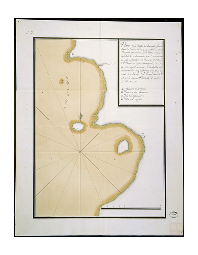
HEZETA Y QUADRA | Rada de Bucareli 1775
A. Situation of the Cross
B. Point of the Martyrs
C. Landing Island
D. Island of deceit

A. Situación de la Cruz | A. Situation of the Cross
SUPERNATURAL Ruby! | JULY 13TH
In our time, step into the minds of the explorers who made first contact with the indigenous people of the Pacific Northwest and relive elements from both recorded and oral histories. Ruby Beach, Olympic National Park is akin to a Castilian Rose in full bloom, treating all available human senses, with logical historical truths, and unique presumptions.
"This is a supernatural place" is how Frank Bennett a local storyteller described the origins of the Hoh River Thunderbird myth to anthropologist Albert B. Reagan, an employee of the U.S. Bureau of Indian Affairs. Supernatural, miraculous, and factual is how we will approach this pictorial alignment of true history. In memory of the many historians who sought the same answers, let the explorer in all, follow the way.
TIMELINE 1700 - 1792.
Looking west imagine no ocean, just earth on the horizon being driven down, while behind us the Olympic Mountains to the east are being forced up. The coastline beneath here could be seen as a frontline in a process of ongoing erosion caused by the active forces of planetary plate tectonics.
1700 | Science At Cascadia Subduction Zone.
Photograph A. Situación de la Cruz | The Pacific Ocean horizon is interrupted by a remarkable island, that is the same detached remanent from the mainland, that was first sighted by crewmembers onboard the schooner Sonora on July 12, 1775. They named this island "Dolores" in a true Catholic sense of the word. Left out to sea, is South Rock. Left nearer to shore are the two rock formations that together comprise the head and ribcage of the King Mimetolith. Center out to sea on the horizon we can see Destruction Island, also known by its original Spanish name, La Isla de Los Dolores (The Island of Pains). Center right approaching shore are the cluster of rock formations, that are all that remain of the notably eroded and nearly totally submerged Landing Island also known by its Spanish name C. Isla del desembarco. On the south side of Landing Island, can be seen the two highest points, that form the knees of the King Mimetolith. Logically speaking, one could speculate that the King Mimetolith factors in a big way, on this miraculous tour!
FIRST TOUR | Moon and Tides Windows of Truth.
Let's get started by examining the first image of the 1775 map, featured in the preceding photo gallery titled Parking Lot > Cedar Creek. The geometrical lines that radiate out from a central point seen on the lower portion of the map, will be utilized again as our location markers, throughout this tour. North orientation, or true meridian, is indicated near the island labeled D which is today called Abbey Island. Officers on both ships more than likely determined where to place the true meridian on this map, by astronomical method, using the North Star as their guide. At the top of the map we see a geographical feature labeled B with the true meridian line shown slightly to the right. This headland is known today as Hoh Head. The north orientation near labels B and D are accurate, however in actuality there is no straight line between these two geographical points as shown drawn. The map's creators were limited by the size of the chart paper, which would explain the absence of two true meridians, one for each ship. Bearing in mind how clumsy the map would have looked with two true meridians running in parallel, we begin to understand why the historic 1775 map is a cleaner composite representation recorded from two different locations, and two unique visual prospective. The next three photographs taken on a cloudy day, are part of the July 14th tour, that have been inserted here, in order to highlight the impact an extreme supermoon low tide would have played during the 1775 Act of Possession. The cluster of rocks seen near shore in the main photograph A. Situación de la Cruz are now seen again fully revealed during supermoon low tide. We can now see the exposed rock cluster as the bedrock of Commander Hezeta's C. Isla del desembarco (Landing Island).
RADA DE BUCARELI
Archivo General de Indias - Sevilla
"Map of the roadstead of Bucareli, situated under the Latitude N. of 47 g[rado]s 24 min[uto]s, and in the western Longitude of S[an] Blas 19 g[rado]s 40 m[inuto]s, discovered and lifted by the commander of this expedition the Theniente de Navío D[o]n Bruno de Ezeta Dudagoitia, in the biage of the discoveries of the northern coasts of California, which he made by order of His Excellency Viceroy Frei D[o]n Antonio María Bucareli y Ursúa in the Year of 1775".
"Plano de la Rada de Bucareli, situada bajo la Latitud N. de 47 g[rado]s 24 min[uto]s, y en la Longitud occidental de S[an] Blas 19 g[rado]s 40 m[inuto]s, descubierto y levantada por el comandante de esta expedición el Theniente de Navío D[o]n Bruno de Ezeta Dudagoitia, en el biage de los descubrimientos de las costas septentrionales de California, que hizo de orden del Ex[celentísi]mo S[eñ]or Virrei Frei D[o]n Antonio María Bucareli y Ursúa el Año de 1775"
A. Situación de la Cruz
B. Punta de los Mártires
C. Isla del desembarco
D. Isla del engaño
Parking Lot > Cedar Creek


B. Punta de los Mártires | B. Point of the Martyrs
JUPITER22 All On Tour: Ruby Beach, Olympic National Park
Truth is solid, fluid, and undisputable, in the mind of an explorer...
| WINDOW OF TRUTH |
Cedar Creek > Window of Truth
WINDOW OF TRUTH > LANDING ISLAND
